Posted on
February 28th, 2024
by Quertime Writer in Images
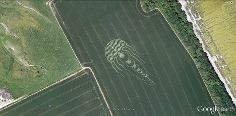
Google Earth is basically global mapping software that provides you with accurate geographical information. It uses satellite images, aerial photography and use GIS 3D globe. If you want to see some amazing things but don’t have the budget, then this article is for you.
In this article, we look at 20 of most amazing and weird things that you can see on both Google Maps and Google Earth. Read more…
Updated on
August 28th, 2017
by Quertime Writer in Web Tools
Google Earth helps you explore the world like never before. You can fly through cities, learn about landscapes and discover about the earth using this amazing tool.
Updated on
July 2nd, 2018
by Quertime Team in Mobile
Offline maps can be very helpful when you are abroad or out of network. If you are looking for the best way to download Google Maps data to your mobile devices, look no further as we have solution for you. In today’s post, we’ll show you some easy ways to save Google Maps data to your smartphone or tablet device so that you can browse saved areas by using My Location and compass mode, even when you’re not Internet connected.