20 Google Maps Tools to Plan Your Trip
Whether you’re heading to Morocco or Montana, everybody needs some help to fully enjoy themselves when traveling. Or, if you’re traveling for work, tools like Google Maps might be just the thing that finds a new route and gets you to that important business meeting on time.
So, here are 20 useful tools you could use to plan your trip.
1. Area Calculator Tool
The area calculator tool allows you to click multiple points on a Google map. This will let you begin drawing the outline of the shape you want the area of. Area is given in square feet, acres, square kilometers, and square miles. If you’re deciding on what to do in a specific area of tourism, use this tool to filter to narrow down the area that you want to explore.
2. Distance Calculator Tool
Click multiple points on a Google map and make a path that you want the distance of. This amount is provided in feet, meters, kilometers, and miles. What does that mean for your trip? Well, you could this if you want to plan out scenic walks or even your total driving distance from point-to-point…so you can have some data to plan your next trip.
If you’re planning a move, for example, you might need this to determine how much a car transporter will charge for car shipping, how much your moving company will charge you, or simply how long the kids can expect to be in the car for!
3. Elevation Calculator Tool
If you’re the nature-type, this elevation calculator tool is similar to the distance calculator tool, except shows a graph of elevation points along that path (instead of just the distance). Besides for hikes, you could use this to tell your incline level on a long job or bike ride.
4. Navigate During Your Trip
Using your old nogging isn’t always the best way to navigate, and that’s especially the case if you’re the leader of the pack. Here are the different button shortcuts you should use during your trip:
- + / – zoom in / out
- left / right arrow keys turn left / right
- up / down arrow keys move forward / backward
- A / D turn left / right
- W / S move forward / backward
5. Draw A Circle
Enter a radius then click a point or enter an address to draw a circle on a Google map You could use this to draw shapes on mountains, circle the area you’d like to travel to, or show different campgrounds if your excursion will feature the wilderness.
6. Geocode Tool
This tool allows you to enter an address to find the GPS coordinates (i.e. latitude and longitude).
7. Google Reviews
Use this feature to find highly-rated businesses for all different types of services. Search for businesses near you by business type, name, or keyword. From food to hotels to getting your oil changed, this is one tool that could save you a lot of bucks in the long run (and make sure you’re spending your restaurant at quality places in the meantime).
From lighter things like finding a place to stop for lunch to bigger issues like finding a car shipper to come and pick up your broke down vehicle, Google Reviews can make sure your money is going into the right hands.
8. Batch Geocode Tool
This tool lets you enter up to 100 addresses to find the latitude and longitude of multiple addresses quickly. You could use this to find the latitude and longitude of the place you’re currently at. For example, if you’re in an emergency and can only communicate your coordinates this way, then maybe you could use this tool for that.
9. Distance From/To Tool
Enter two addresses, cities, states, or zipcodes to calculate the distance between them. If you’re deciding between two places to travel to, eat at, or just drive to for a day trip, perhaps this tool would tell you which route is going to be a shorter trip. If you want to go for a long drive, knowing the time it will take you to drive to and from might help you make a decision as to your destination.
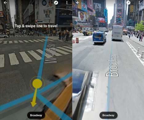
10. Create Your Own Street View
Many people find this street view tool to be creepy, others find it to be quite cool. Recently, Google employees aren’t the only ones snapping 360-degree photos of your house. Supposedly, there are a number of cameras and editing software supported by Google that let people create their own street views.
11. Driving Directions
This is what you probably have used Google Maps for in the past, and it’s still pretty simple. Enter your starting address and your ending address (with up to 10 locations in between) to find out how long it will take, what traffic looks like, and when the best time to leave might be.
12. Traffic Map
When the directions don’t provide enough specifics for you, become your own navigator by using the traffic map. You’ll see roads colored in orange, red or nothing. This indicates that traffic is light, heavy or inexistent. Sometimes, if traffic is building from an accident or something, you might be able to be ahead of the game and take a detour before it’s too late.
13. Google Maps Offline Access
Most people need maps when they have no idea where they are. And when you have no idea where you are, there’s a good chance you’ll find yourself in a rural setting with absolutely no cell phone service.
Fortunately, Google Maps has offline access (which you’ll see when you tap the bottom of the screen). In the pop-up, select Download and download that map. When the map downloads, you’ll be able to see details and info on different businesses in the area and turn-by-turn directions within the downloaded section.
14. Parking
When you’re ready to get out of that car and bop around a bit, Google Maps has a great tool to provide you with the parking situations in your destination, or near your destination. If using iOS or Android, you should find a little “P” logo at the bottom of the screen. In addition, you’ll see tags for LIMITED, MEDIUM and EASY. These tags tell you how long to designate for parking or maybe if you should take public transportation.
15. Accessible Transit Routes
Speaking of public transportation, Google Maps has that covered too. Just enter your desired destination on Google Maps, tap “directions” and then select the public transportation icon. Click “options” under the routes section, and you’ll find “wheelchair accessible” options as well.
16. Trip Itinerary
How many useful tools does Google Maps have? A lot, apparently, and this is another super helpful one. Building a trip itinerary will not only make sure you have a realistic gameplan in mind but that you and the possible group you’re traveling with will all be on the same page.
17. Share Real-Time Location
Google has finally caught up with the iPhone on this one. If you share your location with a specific contact, they’ll see your icon moving in real-time on their map. On Android or iOS, tap the hamburger icon on the top left and select Location sharing. Simply select who you want to share with and how long they’ll be able to see where you are. If you’re traveling with a group, this tool will make sure you’re all aware of where everybody is at all times. Think buddy system, but Google Maps is everybody’s buddy!
18. Customize The Style of Your Base Map
Not only can each person have a different icon, in the tool’s base map layer, select the carat icon and view a variety of different map styles. As if touring the world wasn’t already fun enough…
19. Get an Uber
As a huge part of the transportation industry, the Google Maps tool has integrated this into their platform in order to give people all options when it comes to a car transporter, public transportation, etc.
20. Embed Area Calculator
In the case that you are not the traveler, but people are traveling to you, this is a tool to get to know. It allows you to customize and place the area calculator tool on your website, making sure people head straight to your business instead of getting lost and frustrated along the way.
Tags: google maps, map, web app


